Our class's exhibit was packed up and relocated to Kingsborough Community College, just a few blocks away from where I live ironically.
It's pretty amazing to know that our work is being reused. In particular, that Guy Ambrosino's steel is being re-installed. I feel proud to have initiated contact with him in March, understood the value of what he was doing and voila, have his piece live a little longer.
Tuesday, September 22, 2009
Tuesday, April 21, 2009
Newswalk Condo
1997 - Brooklyn plant of the Daily News closes and relocates in NJ due to inability to print 4 color
1999 - Shaya B. Developers (Shaya Boymelgreen) buys 535 Dean Street with hope to have city pass a zoning revision to have a theater on the ground floor with residential space above.
2002- Condos at 535 Dean Street starts selling. NYTimes art :" To renovate the Newswalk building, Boymelgreen Developers had to convince the city to rezone the site from manufacturing to mixed use, a process that took more than two years.
The 88 apartments in the first offering range from $315,000 for the smallest loft (690 square feet) to $1.3 million for the larger of two penthouses (2,500 square feet, with a 2,500 square foot terrace). Two bedrooms with dens (1,700 square feet) go for $699,000 and duplexes, (1,420 square feet) available only in loftlike one-bedroom configurations, are $499,000 to $519,000. In addition, nine apartments with 30-foot ceilings will be carved out of the first floor.
Community Board 8 granted its approval for the project with some reluctance. ''The problem in the area goes far beyond that building,'' said Dennis Drucker, the board's housing chairman. ''We have a horrendous number of factories there that no longer provide employment. Meanwhile, the residential market is insane. Things that couldn't be given away five years ago are now worth half a million.
''The problem is that very few people who grew up in or now live in the district can afford that, and it means the end of possible manufacturing jobs. Unfortunately, though, we don't have a choice, and that is why our committee with some reservations and requests supported Newswalk. We decided that a live residential building is better than a dead factory.''
Monday, April 20, 2009
Research
These are the buildings for which some information (photos/details, surveys, interviews) has been gathered.
485 Dean Street (Freddys Bar)
495 Dean Street (J Campbell's property)
535 Dean Street (Newswalk)
603 Dean Street (shelter)
636 Dean Street (Soap Box)
648 Pacific Street (firehouse)
545 Dean Street (T. Collins)
182 Flatbush Ave (Triangle Sports)
636 Pacific Street (Atlantic Arts)
800 Pacific Street (Wards Bakery)
In addition, there are general area photos of the subway station, street signs against Ratner, etc)
If I were curator
These were my notes from the mock-up exhibition/review:
1) The blue line of tape was too thick in proportion to the scale of the streetscape. It did not read as an architectural/zoning line.
2)I think there should be more obvious color coding on the board—like color circle or leader lines (possibly in lines of thin tape) to attach the collected data to the street or map location.
3)Photos (i.e historic photos) should be scaled to one uniform size
If I were curator I would take the critics advice and organize each site into TYPE of development – private, partnership, city initiated, organic etc. In doing so, I think the data of each site can be treated uniquely as per the information we have already gathered. I agree with the idea that each site can be portrayed differently. Atlantic Yards for instance may not need a consistent streetscape to define the present context but could benefit from front elevation shots alongside architectural details that hint to existing usages. BAM perhaps can have streetscape images and playbills or theatre literature.
I think the combination of the past and present on the same board is confusing. If the present occupied the main board with the past mounted onto it on .5-inch thick foam core it would help delineate past/present/future periods better.
I think a timeline in a series of rings per year somehow mapped on the floor including all three sites and perhaps branching off toward each exhibition space would be an interesting way of encapsulating everything.


Thursday, April 16, 2009
AY past


WARD PLANS TO SELL ITS BROOKLYN BAKERY
January 23, 1952, Wednesday
Section: BUSINESS FINANCIAL, Page 40, 214 words
The Ward Baking Company will discontinue operation of its Brooklyn plant soon and has contracted to sell the land and buildings for $950,000 cash, which is considerably in excess of its book value, Faris R. Russell, chairman of the board, told stockholders in the annual report issued yesterday. [ END OF FIRST PARAGRAPH ]
BAKERS SEEK TO END WHEAT-SAVING DRIVE
June 28, 1948, Monday
Section: BUSINESS FINANCIAL, Page 29, 146 words
The first paragraph is not available for this article.
GEO. S. WARD DIES; BAKERY OPERATOR; Co-Founder With Brother of the Firm Here Bearing Their Name Stricken in Havana AN EXPANSIONIST IN FIELD Devised Modern Methods and Aided Research Increasing Vitamin Content in Bread
Wireless to THE NEW YORK TIMES.
September 4, 1940, Wednesday
Section: Obituaries, Page 32, 614 words
HAVANA, Sept. 3--George S. Ward, well-known American business man of Havana and New York, died here this morning after a brief illness. He was born seventy-three years ago in Pittsburgh. [ END OF FIRST PARAGRAPH ]
Monday, April 13, 2009

Wednesday, April 8, 2009
Atlantic Yards photos

 obstructed view of history by FCR's construction
 Newswalk Building water tower
 Dean Street across from no. 535
 south side of dean street (east of 535)
 relic of old atlantic terminal

interior shots of atlantic terminal building. it's basically serving as a massive skylight.
Sunday, March 15, 2009
draft research focus
In an effort to build a chaotic (network) “time map” upon a linear/chronological account of what has and is occurring at the Atlantic Yards, my research will be based on leads I would gather from personal interviews. I would use whatever information collected from these interviews to describe the present context—or the context in which these people live. I would like a chain reaction affect to result, i.e. if someone (a “present” subject) shared a memory about the Hot Bird restaurant (a “past” object), my next research step would be to research the restaurant or its owners and follow through with their personal story or connection to the area. It may lead to a dead end but it would allow me to move onto another person to interview. I think the purpose would be to highlight the social aspect of these areas or the human scale that exists within the city infrastructure. I am primarily interested in the smaller community efforts that activate the present context. The past and present would feed each other with information.
My goal would be to remain transparent or as seemingly unbiased as possible and let the subjectivity of those interviewed come to the foreground.
Plausible questions:
How long have you lived here? How long have you engaged in these spaces? Are you parents from here? Did they engage in these spaces? What is different between your experience and theirs? What has changed in the time that you have been here? What do you imagine this place to be like in 5 years, 10 years? Where will you be? What would you want here?
People I’ve tried/have briefly contacted:
Jerry Campbell – owner of
Norman Oder – Atlantic Yards Report
Frank Jump – Fading Ad Blog
Jimmy Greenfield – owner of Soap Box Gallery
Guy Ambrosino – artist exhibited at Soap Box
Tracy Collins – photographer on Flicker
People I’d like to contact:
a) people who tried to landmark the Wards Bakery
b) people who proposed the Prospect Heights Historic District
c) random co-inhabitants of the Atlantic Yards spaces: gas station attendant, auto repair owner
d)
Wednesday, March 4, 2009
March 3rd Exhibition Concept proposal
Our group's ideas for the exhibition concept were as follows:
Vrushti created a historical timeline of events that occurred within the three sites that she thought could be laid out or diagrammed on a floor map. Here is an excerpt:
So, in going back to the exhibition concept, while there may be a linear timeline backbone, we could create these linking ties or associations through images or more text... for instance, the date/year of the opening of the Ward's Bakery and then call out the date/year the bakery was demolished and then link it to the date/year (say, if the steel at the Soap Box Gallery was from the Wards Bakery) the steel from is used as an art/political statement. Or the map could include urban/community milestones, like "Tracy Collins (flickr photo guy) takes his first picture to document the AY activity" or just show random things that existed-- things like footage on youtube. We could even play with the complexity of the date the footage was uploaded onto youtube, versus the era/year the actual footage represents. That may be too complicated. But the point would be to demonstrate that an individual thought that some (old) footage was significant on such-and-such a date. And therefore it is significant.
I like the idea of arguing for significance of what exists or does not exist based on emphasizing the documentation effots of participants ("the actors") of this urban story, ie Norman and Tracy.
The map then could maybe have its own hierarchy-- like historical textbook-like facts (gov't initiated issues/urban renewal projects) versus the public's/small community issues that we could decide are color coded.
____
Post-March 3rd class notes:
Vrushti presented our group's idea with an interesting twist that I hadn't thought about. She interpreted the use of the mangled steel (which I had thought to portray in photographic form) as actually having the physical materials there.
Vrushti created a historical timeline of events that occurred within the three sites that she thought could be laid out or diagrammed on a floor map. Here is an excerpt:
Atlantic Yards:
1955-61- proposal for Dodgers Stadium (for many of the same reasons Nets stadium was proposed for the site); opposed my Robert Moses due to the use of eminent domain to get the land
1963-67- Fort Greene Meat Market designated as Urban Renewal Area
1968-71-Atlantic Terminal designated as Urban Renewal Area; Baruch College campus proposal
1972-74-Special education high school, 12-story Mitchall-Lama Co-ops built, Baruch College campus proposal
1975-17-story NYCHA project built
1976-Fort Greene Meat market razed
----
I though that the timeline would be a good idea for it would seem to tie the past to the present via these urban "milestones". But in light of not having enough time to research all the called-out items and Vrushti's idea of floor map, I wondered if get by with filling whatever research voids we have by "complicating" the idea of the timeline into something that we could refer to as a "time map. " It could be like a network of text and images. Collectively, at our discretion, we could link whatever images or text we want and somehow obstruct the view of linearty.
So, in going back to the exhibition concept, while there may be a linear timeline backbone, we could create these linking ties or associations through images or more text... for instance, the date/year of the opening of the Ward's Bakery and then call out the date/year the bakery was demolished and then link it to the date/year (say, if the steel at the Soap Box Gallery was from the Wards Bakery) the steel from is used as an art/political statement. Or the map could include urban/community milestones, like "Tracy Collins (flickr photo guy) takes his first picture to document the AY activity" or just show random things that existed-- things like footage on youtube. We could even play with the complexity of the date the footage was uploaded onto youtube, versus the era/year the actual footage represents. That may be too complicated. But the point would be to demonstrate that an individual thought that some (old) footage was significant on such-and-such a date. And therefore it is significant.
I like the idea of arguing for significance of what exists or does not exist based on emphasizing the documentation effots of participants ("the actors") of this urban story, ie Norman and Tracy.
The map then could maybe have its own hierarchy-- like historical textbook-like facts (gov't initiated issues/urban renewal projects) versus the public's/small community issues that we could decide are color coded.
____
Post-March 3rd class notes:
Vrushti presented our group's idea with an interesting twist that I hadn't thought about. She interpreted the use of the mangled steel (which I had thought to portray in photographic form) as actually having the physical materials there.
Sunday, February 22, 2009


Wednesday, February 18, 2009
495 Dean Street update
Today I went to the Department of Records to see if a 1940s tax photo is on file for No 495. It is and I've placed an order for a copy to arrive in 4-6 weeks. But, after looking at the blurry microfilm, I do not believe the wood cladding is original. To me, the facade appeared exactly the same-- same window covering shapes, etc., aside from the fact that it appeared to be brick covered. The photo will confirm. But nonetheless, I still feel like the footprint is significant. The assistants at the Dept of Records were somewhat rude so I am planning on just using Pratt Library's sanborn map to investigate this further. If I can remember correctly from today the 1929 Sanborn map that I looked at indicated that there was a weird interruption of the common yard between the Pacific Street and Dean Street properties from 6th Avenue. See here:

I suppose the DoF would be another option to investigate, in case someone with more notoriety lived there in the past that would bolster the building's significance.
However, notoriety is subjective. I think it would be equally significant to study a building, the history of its past and present owners and map out all the connections and networks built around that single building and those particular occupants-- where they worked, their own personal milestones, where they went to school, where they came from. It would be too daunting a task though.
Monday, February 16, 2009
Critique of the 2004 Downtown Brooklyn Plan
The Downtown Brooklyn proposal prepared by the Department of City Planning and the New York Economic Development Corp stands out as problematic marketing material. Approved in 2004, it double-handedly convinced state and city officials to allow for massive changes to occur in Brooklyn while angering small business owners, residents and igniting a network of informal news/activity watchmen. To critically evaluate it in January 2009 is difficult for it appears to lack currency and substance.
Data for the Downtown Brooklyn plan stems from information based between the years 1990 and 2000. This period belongs to the dot-com era which was directly related to the internet and the advancement of internet based technology. The need for spaces wired and built with modern internet cabling may have led companies to seek locations outside of
“
The increase in sublease availabilities began putting downward pressure on rents in mid-2008. By year-end, overall
To claim that a space is available for subleasing suggests that that it is “ready to be occupied in a short time frame” (slide 5), which is exactly what the NYDCP/NYCEDC stated as a goal in re-developing and re-zoning the downtown area. In addition, oddly enough, the amount of square footage now available due to the economic turmoil exceeds the targeted square footage of 4.5 million.
Another issue that makes the presentation slides highly visible as marketing material is the choice of words to describe the
One surprise discovery in reviewing the approved plan is that the nearby Atlantic Yards is technically not within the boundary lines of this re-zoned area. However, visual imagery of a partial city map suggests that Downtown Brooklyn is influenced and connected to eight different surrounding neighborhoods (annotated slides 5). Not many of these areas (if any at all) are connected to the Atlantic transit hub or can be reached on foot. Only a car or circulatory trolley/shuttle would feasibly connect these areas’ cultural resources, some of which are indicated with arrows out of the zone. But new connection techniques aside from sidewalks are not mentioned in the presentation.
While the varied urban environment is considered appealing and an existing asset to Brooklyn, the presentation slides also state that “building on the success of previous development efforts that have retained and attracted companies in NY, the plan would create new retail and housing and foster expanded academic and cultural facilities” (slide 1). The development that qualifies by city standards as “success” is not developed convincingly or backed visually to give viewers/readers proof of this statement. There are no images of existing conditions at street level that city planners consider successful or unsuccessful. In fact, what many critics consider successful pockets of the downtown areas are listed as blighted by city officials. Viewers are expected only to relate to a disconnected architectural street/block & lot map, which requires practice and mental associations to be made in order to understand. Indeed, the most recent large development may have been the MetroTech area. However, it is doubtful that MetroTech is the success which defines this part of
Another issue is the assumption that back-office workers, who are projected to be the new inhabitants of these office spaces, are going to want to engage in
Finally, another poor marketing tool included in the presentation is the use of
Bibliography
*Cushman & Wakefield 4th Quarter Report 2008
NYC Department of City Planning - Downtown Brooklyn Plan (Full)
http://www.nyc.gov/html/dcp/html/dwnbklyn2/dwnbklynintro1.shtml
NYC Department of City Planning - Downtown Brooklyn Plan (Annotated)
Thursday, February 12, 2009

 http://atlanticyards.com/graphics/photos/existingsite_slides.gif
no. 491-495 Dean Street

The buildings shown in the above picture (from left to right) are 491-495 Dean Street. While documenting the structures along Dean Street, 493 & 495 stood out to me because of their use of wood materials (neither brick nor brownstone which is prevalent along the majority of the other building facades in the area). I also noted that 495 is significantly misaligned among the other street-facing facades. This seems minor, however, I think that it is highly likely that it pre-dated the establishment of the boundary lines of the sidewalk, street, building lot or the construction of the surrounding buildings. It also is significantly shorter than all of the other short buildings.
It is difficult to see, but up until recently, there had been a building to the left of 491 which has since been demolished for FCR. These three structures fall within the lines of the Atlantic Yard plan. They are currently privately owned by one individual whose family has collectively owned it for approximately 50 years. In order for the lots to be transferred to Bruce Ratner, the area had to be deemed blighted. The owner however, has informed me that the condition of the interiors is perfect.
During my interview, I asked the owner also whether there has been any attempt to have these structures landmarked or researched the history behind 495. He informed me that he has been told that No 495 is from 1825 and 493 is from 1827. He admitted that he did not have information on the history behind the properties aside from knowing that there was a stoop or staircase in the front of one of them. He also believed that over the years, owners added to the facade, rather than removing the initial old facade layer and replacing it. So its history may be intact. I mentioned that tax photos from the 40s could be found from the Department of Records if indeed he wanted to restore the facades to be granted landmark status. He informed me, however, that it would be pointless to go through the effort of restoring the facades if the city is going to demolish them anway.
Wednesday, February 11, 2009
Proposed Prospect Heights District

What I gather from this proposal is an attempt to cement a boundary line of protection for the old versus the new construction. I haven't found whether the proposed district has been denied or a decision is pending. As far as I know, the district hasn't been created yet. Unfortunately, it does not include much of Dean Street.

Tuesday, February 10, 2009
The function of the stoop

Excerpt from John F. Freie's Counterfeit Community: The Exploitation of Our Longings for Connectedness. Published by Rowman & Littlefield, 1998
"While children received an education at the neighborhood school, the recreational center was the alley in the back of the house or, when adults were not around, the front stoop and front street. Thus, children played within the neighborhood, well within sight of adults who did not hesitate to help form character through the use of discipline even if the child involved was not one's own.
On summer evenings the front stoops became informal meeting places where neighbors carried on conversation well past dark. Even places of business were extensions of the web of relationships that existed in the community."
Signage on Dean Street
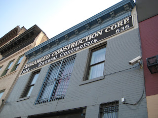
There are multiple forms of signage available to experience when walking along Dean Street in Brooklyn. With the exception of political signs protesting the Atlantic Yards project (a), most of them have been designed and placed with discretion (b); they require up close observation in order to read their messages (c).
Some signs are clearly of a past era (d) and are incomplete (e). Others, like at No. 636, are inaccurate all together, as the contractor left the property 13 years ago (f).
New signage i.e. for No. 618 is fitted to the width of two rows of brick by one wythe of brick (g).
There is a familial, hand-made feel to the collection of signage at No. 640 as well. The fairly standard typography of the Mandalay So sign along with the taped-down IPod Repair sign (h) gives the door and building a sense of utility that is not claiming to be more than it is: a commercial space along a half-residential/manufacturing street.
 (a)
(a)
 (b)
(b)
 (c)
(c)
 (d) <-link
 (e)
(e)
 (f)
(f)
 (g)
(g)
 (h)
(h)


Some signs are clearly of a past era (d) and are incomplete (e). Others, like at No. 636, are inaccurate all together, as the contractor left the property 13 years ago (f).
New signage i.e. for No. 618 is fitted to the width of two rows of brick by one wythe of brick (g).
There is a familial, hand-made feel to the collection of signage at No. 640 as well. The fairly standard typography of the Mandalay So sign along with the taped-down IPod Repair sign (h) gives the door and building a sense of utility that is not claiming to be more than it is: a commercial space along a half-residential/manufacturing street.
 (a)
(a) (b)
(b) (c)
(c) (d) <-link
 (e)
(e) (f)
(f) (g)
(g) (h)
(h)

Monday, February 9, 2009

Saturday, February 7, 2009
Traffic _February 2, 2009
While the footage was taken at different hours of the day, the point was to get a sense of vehicular traffic flow and ambiance on Dean Street as compared to Atlantic Avenue.
graphic design as a tool

Norman Oder at Atlantic Yards Report found a drafted web page for one of the Ratner's developments, which has since been removed, that is telling.
Wednesday, February 4, 2009
attitude towards illegal parking on along north side of atlantic

I bet they can't wait for what's to come.
(p.s. I double parked to take this picture)


Sunday, February 1, 2009
Course Syllabus
Throughout the 20th century, Downtown Brooklyn has served as a laboratory for experiments in architecture and urban design....The area around Atlantic Yards once served as a manufacturing center, and may now become home to one of the country's most dense developments, Atlantic Yards, generating controversy and counter-proposals.
Such change in Downtown Brooklyn is driven by agencies (developers and government officials) that are typically outside of but dependent upon the design community. Examining the history and present of Downtown Brooklyn, we will interrogate and clarify the roles of design in inventing a more just and creative means of "developing" Brooklyn. What will a dense regional center look like? Who will go there, what will happen there? And how will it be designed?
To respond to these questions, we'll explore techniques for researching and exhibiting changes in urban areas. With Downtown Brooklyn as a site, we'll examine how architecture and urban design have transformed the city's downtown, and how these transformations relate to the politics of race, class, and development in New York.
For our final project, students will collaborate to produce a small exhibition of our research, which will be shown in the storefront gallery at the Metropolitan Exchange in May 2009.
Subscribe to:
Posts (Atom)
